 Truckee Meadows 52k Climax
Hills: Minimal until end — Distance: Long — Skill Level: Intermediate — Duration: 2.5 to 3.5 hours
CAUTION:
- Contains several sections of ‘in-traffic’ riding.
- May require crossing traffic lanes.
- Has sections of close contact near high-speed vehicles.
- Has sustained climb near the end
- Heat and smoke can be health issues during Summer months.
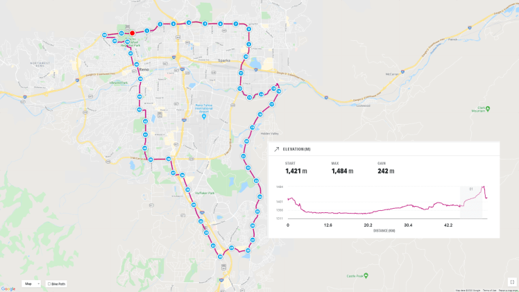
This route is a great route for a long ride with few significant hills. It also includes travel on the Veteran’s Parkway bike route, which is a scenic ride on the eastern side of the Truckee Meadows (the valley where Reno and Sparks are located.)
Kilometers 1 through 12
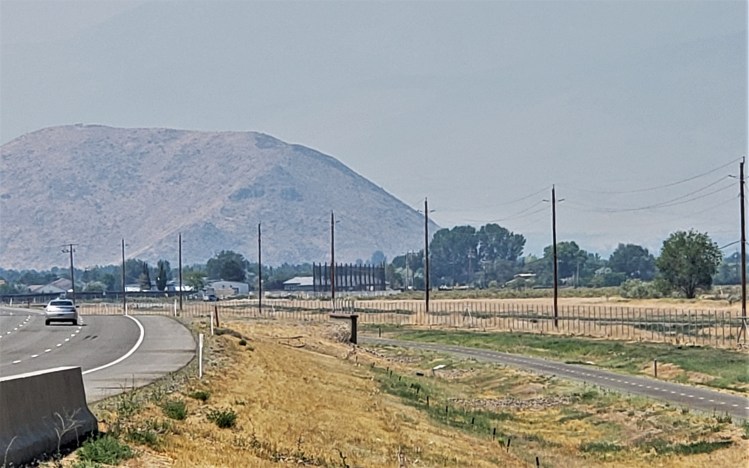
The route starts at the intersection of North McCarran Blvd. and North Virginia Street. The first section runs east from the intersection on McCarran for 8k, then continues to follow McCarran south for another 4k. McCarran is a high traffic, high-speed artery around Reno and Sparks, but most of it has a wide shoulder for cyclists.
Beyond the traffic, there are places where the bike lane shrinks to almost nothing (near Sutro,) and again in the business area north of Interstate 80. In this area, the bike lane and shoulder disappear requiring the cyclist to compete with the traffic.
Kilometers 12 through 28
The next section (12k to the 24k) along the Truckee River and Veteran’s Parkway offers a dedicated bike path away from traffic. After that (24k to 28k,) the bike path is a defined lane on Veteran’s Parkway, which is a wide four-lane street that, at times has a landscaped island divider between the north and south traffic. This section has small elevation changes.
This is the most enjoyable part of the route. It offers a great view of the Sierra Nevada mountains west of Reno, possible wildlife viewing including deer and coyotes, and has no rapid elevation changes.
Kilometers 28 through 36
The turn to the west and then back to the north puts the cyclist back near traffic again, although most of this section includes a bike path or wider shoulder. The two kilometers after the 28k point (see map) follow along Steamboat Parkway and Damonte Ranch Road. These are wide, high traffic, multi-lane streets. At times, a cyclist has to cross the right turn lane from the right shoulder. This creates risk and for me, I stop and wait for all traffic to clear before moving across the right turn lane.
After the 30k point, the route joins Virginia Street and turns north. Virginia St. is quasi-highway at this point with a wide shoulder. It is relatively comfortable riding as long as you are accustomed to loud traffic passing you at highway speeds. The separation between rider and traffic is generally significant until after the 35k point when the shoulder/bike lane gradually diminishes to nothing during the last half of a kilometer of this section.
At the end of this section, the cyclist has a choice to either become a pedestrian and cross at the crosswalk at the intersection of Virginia St. and Neil Road or move across traffic and join the left turn lanes from Virginia onto westbound Neil Road. This is one of the most uncomfortable points in the route if the cyclist is not used to being in traffic.
Kilometers 36 through 39
Kilometers 39 through 52
Plumas at McCarran is a wide street with a bike lane. It is a pleasant ride north back towards downtown Reno. For most of this section, trees line the street and the elevation changes are minimal.
At Plumb Lane, the route heads west, meaning the rider needs to cross traffic to get in the left turn lane or use the crosswalks. After a short distance, the route continues north on Arlington. With a few exceptions, Arlington has a bike lane and it crosses the Truckee River west of the downtown area. The route continues north skirting the west side of the downtown area until St. Mary’s Hospital. There the route goes west again, for a short distance, to connect to Ralston Road, which takes the rider across I-80 and up into northwest Reno.
At this point, the rider will begin a climb a 93 meter (305 feet) on city streets that will average a grade of 2.1%. It is only a Category 5 climb (rating of 1 to 5, with 1 being the most difficult) but at the end of a long ride, it can be taxing. The route continues up Ralston Road to Citadel Road. There the rider takes a left to meet Washington Street, then right on Washington into San Rafael Park. Once in the park, take the first left onto San Rafael Drive and follow the road all the way out of the park to Coleman Drive.
Turn right on Coleman Drive and follow it north almost to the end. Turn left onto Ives Avenue and finish the climb shortly before coming to Keystone Avenue. At Keystone, turn right for a short ride to North McCarran. Turn right and relax as you head down the hill on McCarran ending the route at Virginia Street.
MapMyRide says the ride is just under 52 kilometers.
